Thursday, October 23, 2014

Road Trip in the American Southwest // #6: Monument Valley

Next stop of our road trip in the American Southwest: After Sedona, Grand Canyon, Lake Powell and Antelope Canyon, here is Monument Valley, at the border between Arizona and Utah.

The Mittens Buttes
We all have seen those buttes in movies, series, cartoons, comics and what not, so you can imagine that expectations were high! We left Page in the morning to drive the 250 miles round trip in one day. For lack of time we had decided to not go further towards Moab. I somewhat regret not going further to go around the Lake Powell because we missed on more amazing landscapes like Canyonland and the Arches National Park. But there's always choices to be made... Without a doubt, Monument Valley remains a very majestic scenery. The 300 to 1000 feet high red sandstone buttes that cover this large valley are stunning. We are surrounded by miles of mesas and buttes that shape the Colorado plateau. The buttes are what is left of this plateau after thousand years of erosion. 


The drawback is that the place is very touristic, and the set up and crowd takes away from the magical feeling you'd hope to experience. After paying the fee at the park entrance, everybody drive their car to the parking lot at the end of the road, where, needless to say, sits the unavoidable souvenir shop/restaurant/hotel. The site is part of a Navajo reserve, and it is Navajo Indians that collect the entrance fees. The National Parks Pass is not valid here. (It is in Grand Canyon, Bryce Canyon, Zion Park, to name the few other parks in the surrounding.)


The visit is done by car following a stony sandy lane, either in one's own car (be sure it is not too low so it doesn't scrape the ground), or with Indian's guides. The road zigzags in between buttes in a loop. It is permitted to stop here and there but forbidden to get outside the tracks. All these buttes are considered sacred for Navajos Indians. It is a little disappointing to not be allowed to wander freely and to have to share this only road with all the other tourists, but it is worth the journey.  If not enough time, or if you don't want to pay the fee to get in, I think it would be acceptable to only drive by the park, if possible from East to West, because the westbound view as you get close to the park entrance is amazing! You can stop on the side of the road where Forest Gump stopped running, and take a pretty photo! 


"Forrest Gump ended his crosscountry run at this spot"

Unlike what we'd think, it is not extremely warm in the area: about  85 degrees in the summer. We went there in April and it was much less than 70 degrees even in the middle of a very sunny day. It was also very windy. 
Last advice: Native Indians do not change hour throughout the year, so I'd recommend to be careful about the time difference depending on the season...


Friday, September 26, 2014

Let's take a walk at the cemetery

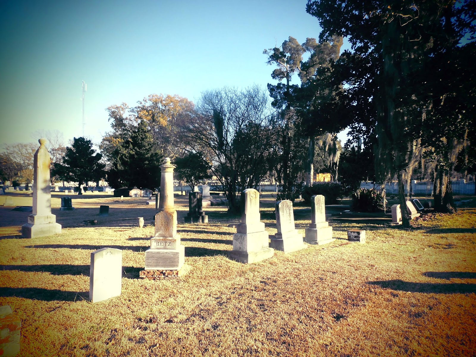
Since Halloween is approaching, let's put ourselves in the mood... I don't know about you, but for me, walking around in an old american cemetery brings back a lot of memories about american series or movies I watched during my teenage years. It just doesn't look like the ones in France. I must have watched Buffy a little too much. The old tombstones are not straight, a lot of them don't have a base, grass grows on nameless empty plots, as a result alleys look very unorganized, it gives it a spooky feeling, but I find it all rather pretty. 

Here is one of the oldest cemetery in Baton Rouge: Magnolia Cemetery


It is a national historic site, where a lot of local personalities are buried. It was  the site of intense fights during the Battle of Baton Rouge on August 5, 1862. Union soldiers were camped on the west side of the cemetery, and the Confederates to the East. 
When the battle started, the northern forces were directed towards the Mississippi levee (to the west), because the Confederate army was waiting for relief from a battleship gunboat coming from Vicksburg (located further up the river in the State of Mississippi). Unfortunately for the South, the boat's engine broke down several time between Vicksburg and Baton Rouge, and eventually had to be destroyed by its own crew, in order to not be taken by the Union. It was blown up close to where Huey Long's bridge now crosses the Mississippi, just north of Baton Rouge. On the ground, the Union soldiers were then able to block the Confederates and push them to retreat. 


During the battle, tumbstones served as cover from bullets and bombs. One can still see traces of it on some stones or trees. The cemetery has a common grave filled with Confederate soldiers who fell during the battle. They were all buried on site. Union soldiers who died during the battle were transported out of the battle field and buried individually in what is now a federal cemetery, right accross the street. That cemetery looks much cleaner by the way: rows of neat white little stones typical of a military cemetery. 

Baton Rouge has grown a lot since then and now the cemetery is in the center of the urbanized area, between Florida Boulevard and Main Street. It's all ugly around, but the cemetery makes almost for a pretty public park, with big oaks, and old stones.  


Monday, September 15, 2014

New Orleans Red Dress Run!

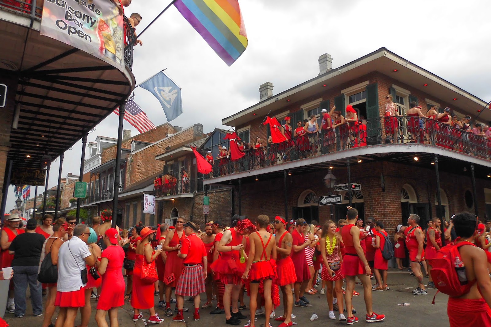
It was last month, in the seeping heat of August: New Orleans Red Dress Run. An annual event organized to gather funds for charities. It's fair to suspect that they don't only run, of course. Truthfully many don't run at all, but join the party in the French Quarter. It's yet another occasion for Bourbon Street to get filled with party-goers, but this time, all of them in red dresses!

Bourbon Street

How did Red Dress Run start? 

The Hash House Harriers are the biggest running club in the world. Their first red dress run happened nearly by accident: On August 7, 1987, a young lady wearing a red dress is arriving in southern California to visit a high school friend. She ends up shortly after in Long Beach, where her friend intends to introduce her to this zany running group called the Hash House Harriers. One member, noting her gender and attire, urged that she “just wait in the truck” until her host returned. With that goading, she ran into history sporting her red dress and heels. 
One year later, to commemorate the event, the San Diego Hash House Harriers sent “The Lady In Red” an airline ticket to attend the inaugural Red Dress Run. Hundreds of male and female hashers adorned themselves in red dresses for a spectacle widely covered by California newspapers and TV news. In addressing the crowd, The Lady In Red suggested that Hash House Harriers hold the Red Dress Run annually as an occasion be used to raise funds for local charities.
This tradition quickly spread to every corner of the globe. The New Orleans Hash House Harriers attracted 7,000 participants to their Red Dress Run in 2010, raising more than $200,000 for local charities.


Our group of cheerful chaps joined the crowd late in the morning. French quarter bars, sidewalks, and streets are packed. It's very hot, and very humid, and everybody starts dripping sweat very quickly, even without running. People, young and old, drink and dance inside and out. For those who know, this could compare to the southwestern France Feria. By the late afternoon we all are worn out, a good nap is a must, in order to make it to round 2 later that evening. Most friends in our group are staying in hotel rooms to not have to drive back to Baton Rouge. I now have my "second home" on site, even better... I ended up napping until the next morning. Verdict: partying is getting harder and harder these days... 


Thursday, September 4, 2014

A little toilet story

The first experience of the public bathroom in the USA can be quite a surprise. Generally speaking, they score on cleanliness, but totally lose on intimacy... As shown in this photo taken at work: one foot of clearance between the ground and the bottom of the partition on every side. For people often so individualists and puritans, it can be disconcerting.  

And there is that thing that I had never seen in Europe: the toilet seat with a whole in the front... Why isn't the toilet seat a full round?! 
The answer to this existential question: Of course, the hole is here for sanitary purposes. In sitting position, the full oval lid sometimes has spatters underneath and forms a nest of germs much more concentrated than with the slit version. 
I'll let you look into that situation next time you cross the Atlantic...


To wrap up on the fascinating differences we find in public bathrooms: 

  • The disposable oval paper lid sheets, with a hole in the middle, to cover the toilet seat and sit ones butt on a clean surface.
  •  The automatic soap dispensers where you don't push on anything for the soap to get out. 
  •  In the same category, the automatic tap so you don't have to touch the tap after you washed your hands.
  • And the automatic flush that is supposed to sense when you are done doing your business so you don't have to flush manually... This one has left me perplex more than one time. At first because of wondering where the hell they hid the flush handle or button, or for not getting up quickly enough... Even passed this stage, i found myself several times looking down and waiting for the flush to do its job and trying to find a way to wake up the sensor that hadn't sensed anything in the first place!! Sometimes technology just doesn't measure up...  

Wednesday, August 13, 2014

Tubing


It's summer, and it's hot. Very hot. In Louisiana, summer temperatures fluctuate between  90 and 95 degres and do not go below 70 at night. On top of it humidity levels are between 70 and 90 (= 90% moisture in the air), which means felt temperatures are easily 5 degrees over the real temperature. So actually we spend summer avoiding the sun and live with the AC. 

There's something I learnt since I've moved here, it's that when humidity climbs above 40 percent, the damp air makes any temperature over 80 degrees Fahrenheit feel hotter than what the thermometer actually reads. Sorry, I'm showing off my knowledge here, after all we never ask ourselves questions about heat effects in Paris... 

So in Louisiana, additionally, we have neither pretty beaches, nor mountain lakes and rivers, nor other normal places to spend summer vacations. However, we have a lot of brownish rivers that don't flow very fast. Among others, Amite river and Bogue Chitto. So what do we do to cool down?! We float down the rivers ass inside a rubber ring. Here they call that Tubing!


A tubing day: 

Upon arrival, everybody pay for its tube and, if needed (but very much recommended), for an additional tube to put the ice chest on. (Do not forget to bring your own ice chest). We leave all our stuff in the car: towels, clothes, which we won't need until we come back. Then we jump into a shuttle, often an old beat up yellow school bus, to reach to launching spot located upstream. We choose our tubes, and before to get in the water, we tie them one to another with a long rope. We are not towed by a boat, it is not a thrill ride... The goal is only to let yourselves go with the flow during approximately 4 hours, hat on the head and beer in hands. Pretty much a floating pic nic... (Attention, glass bottles are forbidden). And we stop once in a while on the sand beaches along the river. We can swim, play freezbee, ball, or whatever. 


Of course, at all times the risk is to come accross some creatures like snakes, alligators, giant spiders and other lovely Louisiana residents. So the advice is, if possible, to avoid floating under tree branches that are in the way on the river banks. Sometimes you don't really have a choice (or we were just not good at it), but you'll certainly collect unwanted stuff on your way. In reality it is very not likely to come accross an alligator. They rather live in swamp's stagnant water. I've never seen snakes either, either in Amite or in Bogue Chitto.


Aside from these little hazards, that were more fun than anything in the end, it is a very pleasant experience. Especially when the place is not packed with drunk, loud, obnoxious people. We sometimes meet some annoying individuals, but also nice local folks. 

With this, it's a little late, but happy summer anyway! But most importantly, bring on the fall! 


Wednesday, August 6, 2014

Road Trip in the American Southwest // #5: Antelope Canyon and Horseshoe Bend

If there is a place to not miss if you drive by Page, it's Antelope Canyon and Horseshoe Bend. Both splendid! And to make things even better, they are both very close to each other, making both visits doable one after another in one morning or one afternoon easily. 
There are two "Antelope Canyons", the Lower and the Upper. The canyons are both located close to one another and are on Navajo land. I have read that they are quite different from one another, but I don't know if it is worth visiting both. Fees are pretty pricy! Almost $30 per person if I remember well, for a tour that last approximately 30 minutes. Add to that the $6 fee for a standard permit required to enter Navajo territory. There is no reservation required, you show up, write your name down on the list and a Navajo guide takes groups one at a time. 


We visited Lower Antelope Canyon, which is narrower to climb into than the Upper. From pictures I have seen, the Upper Canyon is at ground level, seems to be flat and the canyon walls are wider. The hike is much easier. In the Lower canyon, you will have to climb steep metal stairways up and down to make your way through it.


For optimum lighting conditions, it is better to visit the canyons on a bright cloudless day between 11 a.m. and 1:30 p.m. when the sun is overhead. We were lucky to be there in April, which also seems to be one of the best time of the year for good lighting and weather conditions. The canyon can be flooded after it rained... It has been closed for weeks at a time in the past. And it is particularly prone to flash floods. Even when rain falls miles upstream from the Antelope Canyon slots, water can funnel into them with little prior notice. In 1997 a terrible flash flood killed 11 tourists including 7 from France. The group went into the canyon despite the fact they were warned not to go because there was a storm about 20 miles away. The rain from that storm traveled the distance and flood the canyon.

  
All along the canyon the colors and the flowing shapes in the rocks are absolutely amazing. Our guide pointed out a few interesting shapes carved in the rock. Some were more obvious than others, like the two faces in the pictures below. The only downfall is that you are not alone in there... As such it can be tricky to take pictures without people ruining your shots... Photographers have the option to pay more money to stay longer in the canyon. I assume that way they get a chance to not have anybody around in between two groups coming down with a guide.

 
Just a few miles away, right outside of Page, is Horseshoe Bend, a beautiful meander of the Colorado River. You will have a quick 10 minutes hike in the sand before to reach the cliff. It is short but can be pretty hard, in the sun and heat, to go back up to the parking lot. Though the view is totally worth it!


I remember spotting the tent of a lucky guy camping by the river. Personally I don't know any information about navigating down the river but it must be a blast. One more thing, I tried to take photos of this meander by every angle to get a full view of it, but you'll figure it out yourself, it is quite tricky to get it all from left to right as well as from top to bottom!

Thursday, July 17, 2014

Road Trip in the American Southwest // #4: Page and Lake Powell

Lake Powell is a reservoir on the Colorado river, that sits on the States of Utah and Arizona. It was created after the construction of Glen Canyon dam in 1963, and it's the second largest man made lake in the United States. Planet of the Apes was shot there in 1968 and 2001. 


It is a major vacation spot, especially for water sports lovers. Indeed there are almost a hundred side canyons with red and ocher rocks, that are only accessible by boat, canoe or jet ski. Even though it will cost you an arm, the thing to do is to spend at least a day or two on the lake to be able to discover some of its nooks. Rainbow Bridge particularly, which is the biggest natural bridge  known in the world, is only accessible by boat and it takes almost two hours to get there. (The lake is 300 kilometers or 180 miles long). We did not do it, but if you come as a group, and that you have time, and money, it might be interesting to rent one of those house boat to stay in the middle of the lake. 


The little town of Page, next to the lake, was founded in 1957 to serve as a housing community for workers and their families during the construction of Glan Canyon dam. Its site was obtained in a land exchange with the Navajo tribe. For us tourists, it serves as a place to sleep when visiting the lake and everything around: Glen Canyon National Recreational Area, Antelope Canyon, Horseshoe Bend, etc... There is nothing interesting to see in the town itself. Though as you drive by, you'll be able to notice the succession of churches along South Lake Powell Boulevard: Episcopal Church, Lutherian Church, Church of Jesus Christ of Latter Day Saints (the Mormons), First Baptist Church, etc.... In short, they are all contained in the same place, in buildings that look nothing like churches. A dozen of cult venues for such a small town seems astonishing, but religion occupies a very important place in the United States. And above all, there are different churches, different religious denominations. When one comes from France, where there are mostly catholic churches, and often one per village, it inevitably seems puzzling. Let's say that it gives us the opportunity to mug up on all the branches of the Protestant Church... 
Aside from that, oddly I ate the best croissant I've ever had in America! It was at the "Blue Bakery Coffee and Wine Bar" on North Navajo Drive. But let's not get carried away: it was a croissant that had the taste of a croissant and the consistency of a croissant. To me it is now worth getting carried away. 


Tuesday, June 17, 2014

Road Trip in the American Southwest // #3: Grand Canyon


Grand canyon, the inescapable destination of our road trip. We've all heard about it and seen so many stunning pictures. As a result I had almost anticipated a deception. But no, it did not disappoint. The first few seconds when you approach the cliff for the first time are truly breathtaking. 

We had made sure we arrived about two hours before sunset because that's when the light is the most beautiful. During these few hours we went from a vista point to another on Hermit Road, to the west of the park. A free shuttle takes you to each of them. You can get in and out of the shuttle as you please, or, if you have time, walk along the path that follows the cliff and links every vista point to one another. 


After one or two stops, we ended up waiting for the sunset at Hopi Point. Of course we were not alone. If your thing is to be alone in the nature, it's not necessarily the best place to catch the sunset... That time of the day is very popular for visitors and photographers, and we were in the middle of quite a crowd. Of course it's more than likely the same thing everywhere anyway... In the end I don't really understand all the hustle and bustle about not missing the sunset. All those people are massed in the same spot to capture those few seconds. Though the best time is the few HOURS before the sun disappears behind the horizon, when it makes hues of orange all over the rocks, really not the last few minutes. Plus you freeze your ass off afterwards. (We were there late April) Just saying.


Once it was dark outside, we went back a few kilometers south of the park entrance, in Tusayan, where we had booked the hotel. By the way, another drawback to waiting till the sunset before to leave is that obviously you are not alone trying to get back in the shuttle... It's kind of a pain... Anyway, we were staying in Tusayan because there was nothing available inside the park even when we booked online about a month before. The town has no merit, just a few hotels and a few unappealing places to eat. Though it really didn't matter much as we were there only to sleep.


The next day we got back on the road along East Rim Drive. Our first stop was Shoshone Point. This vista point is not indicated on the road, but was in our tourist guide book. So you got to look for it a little bit... It's also less convenient for some people because you have to walk a little less than a mile to reach the cliff. That seems to discourage most tourists. It made it only better for us. We arrived there in the morning, alone in front of this spectacular landscape, and I think it was my favorite!  


Our second stop was at GrandView point. It's the departure point of a hiking trail which goes all the way down the canyon and goes back up on the other side on the north cliff. You have to plan two days for that, with a night at the camp in the bottom of the canyon. We hadn't planned that long hike in our trip, but we walked down the trail a little bit just to get a taste. The trail is very steep and narrow, and personally, I think you might want to stay away if you're scared of heights! Well, maybe I'm a bit wimpish... It's actually not the scariest one at all but I will get to that in a future post. Narrowness and steepness are not even the most dangerous aspect of that hike. The most common accidents are caused by lack of hydration, and it is reminded to you everywhere on boards where the trail begins. Warnings are illustrated with not too funny stories of fatal accidents. 


Finally, Desert View Watchtower, the last vista point before to exit the park on the East side. Out of the few places we stopped at, this one was the only one where we caught sight of the Colorado river at the bottom of the canyon. Practical point: there is also a gift shop and a little cafeteria.


We ended up exiting the park in the early afternoon in direction of Page. A few weeks earlier, Highway 89 collapsed, cutting off the city from the south. We had no choice but taking a detour through Highway 160 and 98, which doubled the normal distance. Not so cool. However, on the road, just before Tuba City, a stop to an Indian site tempted us. A road sign showed we could see dinosaurs fossils and footprints. Upon arrival on the parking lot, you will notice there is no price indication. They will show you where to park, escort you outside your car with some enthusiastic "this way, this way!", they will tell you to leave your camera in your car as pictures are forbidden. Before you even had the time to say anything, they will start guiding you from fossils to footprint (to be fair, that was pretty cool). Then, after 5-10 minutes, they will walk you back to the parking lot asking you for money and trying to force your hand to buy the local merchandise. It kinda feels like you fell in a big tourist trap. I wish a fixed price was given up front so you can at least judge if you want to be taken on the tour or not. But it must be said that Indians do their business as good as they can... It is not easy to compete when all their land has become National Parks and is now in the hands of the government... It was the first time I had seen such amazingly well preserved dinosaurs remains just here in the open, so I do not regret the stop. Too bad we have no pictures to share though!

Wednesday, May 7, 2014

Road Trip in the American Southwest // #2: Sedona


Leaving Flagstaff in the morning, we head out to spend the day in Sedona, about 45 minutes away. After a few switchbacks to go down the canyon, we first end up in a narrow and verdant valley. Just a few more miles and we arrive in the town of Sedona, where we quickly stop only to buy something to eat for our pic-nic. Then we continue on driving a little bit further south until the Chapel of the Holy Cross. It's a pretty vista point with a tiny modern chapel built in 1957, at the top of a small hill. A very small dirt path starts from the parking lot and leads you away from the crowd of tourists who come up the hill to the chapel. We walk down the path for a few minutes to take advantage of the views. The contrast between the lush vegetation and the red rocks formations that surround you is what makes this place so beautiful in my opinion. It's different from the other typical arid landscapes you can see in this region. 

View of the mesas from the Chapel of the Holy Cross


After this quick stop, we get back on the road to go further south, and stop in the parking lot located just north of the village of Oak Creek. The hiking path (4.5 miles) makes a loop around Bell Rock and Courthouse Butte, two huge rocks, one of which known to be a "spiritual vortex". A lot of people in pursuit of spiritual harmony come to Bell Rock to revitalize themselves. Sedona is considered a "New Age" capital, and its touristic industry is catering to supporters of this spiritual movement. It is possible to climb up Bell Rock, or you can also simply go  around it. We haven't walked into a lot of people when hiking the 4.5 miles loop, which made the experience even more pleasant. Plus the path is more or less flat all along. 


In the end, this was a very good foretaste of the rest of our journey... I highly recommend it.